Trek Diary : ONE STEP CLOSER - EBC (PART2) Documented & Written By Sachin Kable
Contd.......We were finally in Kathmandu to begin our journey.
Caught an early morning flight from Kathmandu
to Lukla,The runway I believe is one of the shortest in the world and has
airplanes landing on a slightly uphill slope as they head straight for the
mountain side.
The flight to Lukla
is a 40min, nail biting flight through the snow clad ranges. But you find a
sudden sense of peace when you peep through your window to see the The mighty Mount
Everest.
It’s a quick landing and an immediate exit out of the airport, the exit gate is
full of porters waiting to get hired. If you are thinking of hiring one, this is the
best place becase as you go higher their charges increase or you may not even get
one.
Trek Itinerary :
Day1: Lukla-Monjo
Day2 :Monjo-Namche
Bazar
Day3 :Acclimatization@ Namche Bazar
Day4 :Namche Bazar-Tenghboche
Day5 :Tenghboche - Denghboche
Day6 : Acclimatization @ Dengboche
Day7 : Dengboche to
Lobuche
Day8 :Lobuche to
Gorakhshep to EBC to Gorakhshep
Day9 :Gorakhshep to
Pangboche
Day10-Pangboche to
Namche Bazar
Day11-Namche Bazar to
Lukla
Day12-Lukla to
Kathmandu.
DAY 1 - Lukla to Monjo
Altitude: Lukla-9302
ft
Monjo-8563 ft
Altitude Loss: 739 ft.
Date: 9th March’15, 9.30AM
Trek Distance:
10.4km
Time Taken: 6 hrs.
Temperature: 10° to
21° C
Gear: Track pant,
Polyester T-shirt, Windcheater, sun cap
Hotel: Monjo Guest
House
Expenses: NPR 1500/-
 First day of the trek,
bright sun, blue sky, warm air and we were full of energy. We hit the track and
started walking, chatting, adjusting our backpack several times so that is sat correctly
without pain, however reality hits you when your backpack starts feeling heavy and your back does get sweaty.
The hike from Lukla
to Monjo is mostly a descend for 3 to 4km and after that it is a mix of both. When you see a steep ascent followed by descend you are
near Monjo.
If you feel really
tired there is another option of staying at Pakhding, just an 1 hour before Monjo.
We reached Monjo around 4pm and as we got close to sundown
the temperatures began to drop compelling us to switch into our warm clothing. The home was a quaint wooden cabin , definitely warm and very welcoming.
Hotel owner served us
with much needed hot herbal tea and some snacks, I had a nice hot water shower (
knowing that this would be a luxury I would crave for over the next few days) and retired for the day only to rejuvate for the next leg.
DAY 2 - Monjo to NamcheBazaar
Namche Bazaar – 11286 ft
Altitude Gain: 2723ft.
Date: 10th March’15,
Start Time:
11.00AM
Trek Distance: 5.1km,
Time Taken: 5 hrs.
Temperature: 5° Centigrade.
Gears: Track pant,
Polyester T-shirt, Windcheater, sun cap.
Hotel: Kumbhu Lodge
Expenses: NPR 2200/-
Permits for the treks in this region are issued at the end of the Monjo village at a cost of NPR 1500/-.
The route passes
along Dudh Koshi river, beautiful Rhododendron trees, surrounded by huge
mountains, trek through rocks and bright sun light.
We crossed 3 bridges
before starting our final ascent for Namche bazaar, it is very tiring and
almost steep all through .
 We refilled out bottles at an arrangement created for
trekkers by the Nepalese government, rested for some time, clicked some photographs,
had the much needed energy boosting dry fruits and started climbing again.
Reached Namche Bazar at around 3.30 pm, We chose to rest at the Khumbhu
lodge one of the most expensive and well known stops in this village.
We had a
sumptuous lunch @ 4pm and crashed soon after. The dipping temperatures really
squeeze the energy out of body and you tend to feel a lot more tired that you
actually are.
Altitude: Namche
Bazaar – 11286 ft
Date: 11th March’15,
Temperature: 5° to
15° Centigrade
Gears: Soft shell
pant, Polyester T-shirt, Thermal, Windcheater, sun cap
Though it was called
Rest/Acclimatization Day, it was not, we had to visit Khumjung Village and come
back.
It is very important to train your body to climb and then return to lower altitude, it
help our body to acclimatize faster.
Also it is during this short trek that you get the first clear view of the Mount Everest, there are two route to reach Khumjung village.
One is
steep and other is normal, from the mountain side of Namche, follow a highest peak
and you are on
right track to Khumjung.
For other route take a left from Namche, ascending in
the direction of helipad and the route will take to the same location as route
one.
We reached top, it was heavy snow all over, temp at the top was in the
range of 1 to 2 deg even @ 11am.
The route was full of snow, mud and slush. We
had started at around 9am and return back by lunch time by 1pm, had lunch, relaxed a while and enjoyed peace in this paradise.
 Altitude:
Namche Bazaar – 11286 ft
Tengboche-12600 ft
Altitude Gain: 1314 ft
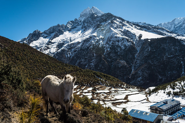
 Definitely stop for lunch in this area as there are a number of tea houses and will provide you with options.The following trail bestows you with the views of great Mount Everest, Lhotse,
Pumori peaks and Ama Dublum on your right all the way till Tyangboche.
Day4-
Namche Bazaar to Tengboche
 Altitude:
Namche Bazaar – 11286 ft
Altitude:
Namche Bazaar – 11286 ftTengboche-12600 ft
Altitude Gain: 1314 ft
Date: 12th March’15,
Start Time:
9.00AM
Trek
Distance: 8.6 km
Time Taken:
7 hrs.
Temperature:
2° to 12° C
Hotel:
Himalayan Lodge
Expenses:
NPR 2000/-
Day 4 hike was a flat walk for about 80% of the route but the last climb of almost 2000 ft from the Dudh Koshi River after we cross
the bridge was strenuous.
 Definitely stop for lunch in this area as there are a number of tea houses and will provide you with options.The following trail bestows you with the views of great Mount Everest, Lhotse,
Pumori peaks and Ama Dublum on your right all the way till Tyangboche.
We
reached the lodge , holding on to our aching muscles and sweating although at near freezing temperature and in desperate need of cup of hot tea. The lodge was full of trekkers and each ones enthusiasm only rejuvenates you.
Day 5-
Tyangboche to Dingboche
Altitude:
Tyangboche-12600 ft, Dingboche-14340 ft
Date: 13th March’15,
Start Time:
8.30AM
Trek
Distance: 10.7km
Altitude
Gain: 1740 ft
Time Taken:
7 hrs
Temperature:
5° to 10° Centigrade.
Gears:
Track pant, Polyester T-shirt, Thermal, Windcheater, sun cap.
Hotel@
Monjo: Sonam Lodge
Expenses:
NPR 2500/-
Started off
early in morning after a nice and healthy English breakfast of basic porridge and eggs. My backpack had started giving me trouble , the daily wear and tear had bent the metal plates of my backback and it was not resting properly on my shoulder and
load was not uniformly distributed on body. Our hip is suppose to take
the maximum load, however the complete load was acting on my shoulders.
This route is completely snow laden and the track marks were also not
clear, we lost the track and proceeded in the wrong direction. After 15 to 20 min
walk, we realised we are on wrong track and not a soul was there to ask for
directions, we were too long lost to turn back and went on with our instincts and finally joined the main trail.
 Trail is the mix of all terrain, snow, rocks, ascend, descend,
plans, river and bridges. For us it was the longest trek till now, not
any sign of Dingboche in sight.
Everybody on the way tells you different timing
to reach the Dingboche ranging from 2 hour to 4hour.
After crossing a bridge of
Dudh Koshi river there was a ascend of 30min. It was past 3 pm and the temperatures started to drop and weather condition got worst, heavy winds followed by snow
fall worsened the condition.
The climbing mountain was full of loose rocks and they
started to rollover as we approached the mountain top which I hoped would be the final stop at the village of Dingboche , but it was a gorgeous plan terrain completely covered with powder like fresh snowfall.
After another hour we finally made it to Dingboche and
checked into Sonam Lodge.
Day6-
Dingboche Acclimatization
Date: 14th March’15,
Temperature:
1° to 7° Centigrade.
Gears: Soft
shell pant, Polyester T-shirt, Thermal, Fleece Jacket, Windcheater, Fleece Cap.
Hotel:
Sonam Lodge
Expenses:
NPR 2000/-
I repeat acclimatization day does not mean a day of rest and we chose to hike up a small mountain trail in the village and visit a Gompa at
the top, its approximately a 1500 ft hike and a good short trip to acclimatize your body.
Here I really started to feel the scarcity of oxygen in
atmosphere, even the climb to the first floor dining hall was a task.
We gathered our days pack, water bottles and set out.It was a very steep ascent without any defined route but with only the peak visible.
The mountain side was covered with sea buck thorn bushes , locals use these berries to make local tea . The climate was changing for the worse so we decided to turn around and made sure we reached base by 12 noon.


0 comments